Zaragoza - Campus routes by bike
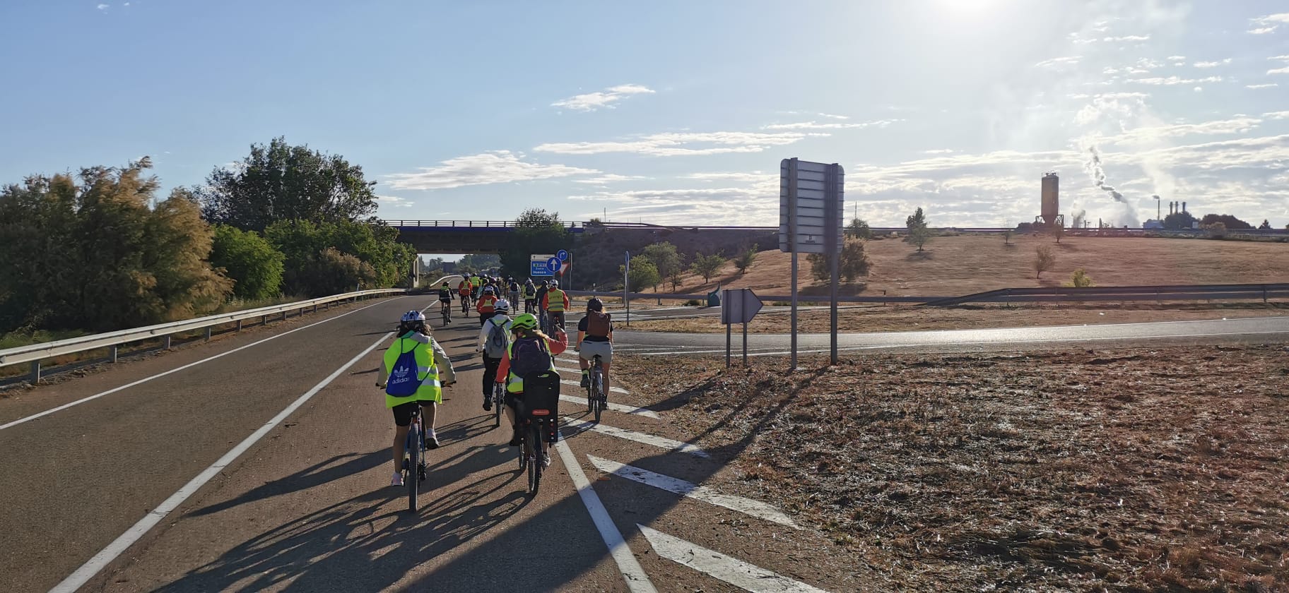 Photo by Javier Rodrigo
Right margin route closed
The path that runs along the right bank of the Gállego River (the route named "Azud - Campus (right bank of Gállego)" in the final table) is blocked by landslides between waypoints 14 and 15, where it passes next to a wall enclosing a plot of land very close to the river itself, at least as of 2025-02-18. One option to bypass this point is to temporarily exit onto the Cogullada road, which runs opposite the walled plot of land.
Currently, I work at the Aula Dei Campus, about 15 km from Zaragoza. Although there are several options for getting to the campus by bus, in my particular case, the combination of routes and schedules is not favorable, so from the beginning, I chose to go by bike. After a few days of testing, I adjusted the route and equipment to make it more convenient and safe. In this post, I list the different options I have come to know and describe, in my opinion, their pros and cons.
Problems and solutions
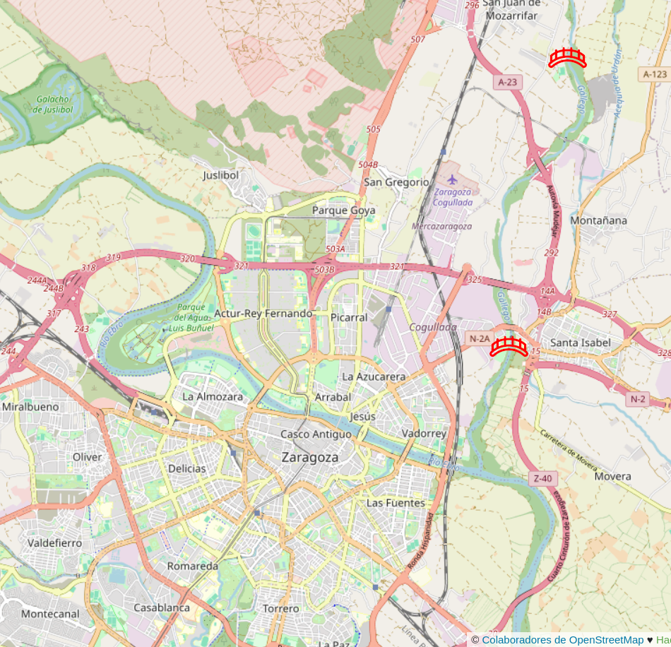
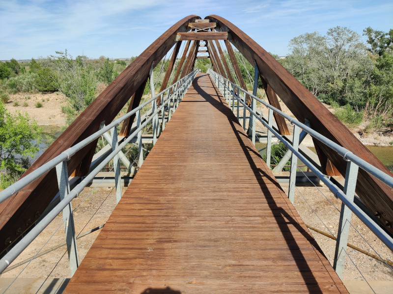
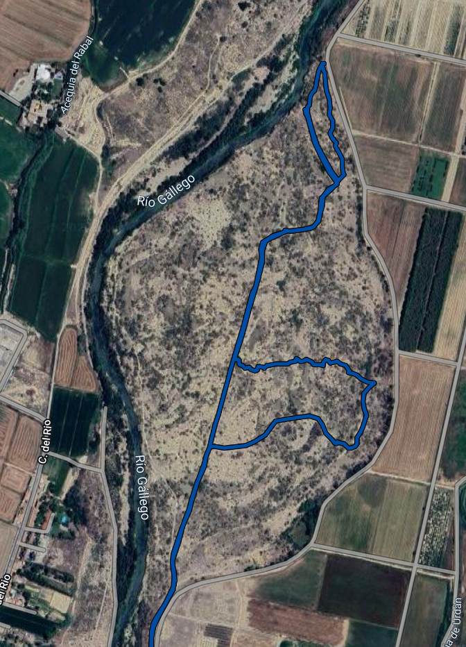
It should be noted from the beginning that unfortunately, access to the campus by bike is not very favorable. On one hand, there are natural barriers such as the Urdán canal and especially the Gállego river, for which there are very few crossings. If we don't consider the road bridges, there are only the pedestrian walkways of Santa Isabel and the one near San Juan de Mozarrifar, as indicated on the following map. The photo below the map is of the second walkway.
On the other hand, the access road to the campus (A-123) lacks a shoulder for most of its route, has a speed limit of 70 km/h, many entry and exit points, and considerable traffic from tractors, trucks, and buses (especially at the start and end of the workday), which makes it unsuitable for cyclists in my opinion. However, avoiding the roads brings some drawbacks that we are going to analyze.
Bike dirt accumulation
The paths are very dusty in summer and become muddy with puddles in winter. Both situations dirty the bike, especially the dust in summer, which affects the transmission (chain, chainrings, and cogs), hubs and pedal axle. For mud and puddles, the best solution is to have fenders on the bike, although in my particular case, I cannot (nor do I want to) install them.
Considering both problems, I have still chosen to use the rural paths and clean the bike as often as needed. However, there are certain times, after several days of rain for example, when it’s useful to have an asphalt alternative. For this situation, and in my particular case, I use the road that connects San Gregorio with San Juan de Mozarrifar, which ends at the Cogullada road, another good alternative if accessing from an area northwest of Zaragoza. Both road sections have little traffic and a speed limit of 50 km/h. From the Cogullada road, you can access the walkway near San Juan by heading towards the San Juan football field.
In any case, in terms of minimizing cleaning and bike maintenance, the best route in my opinion is the one shown to me by my colleague Magí, which uses the Santa Isabel walkway to cross the Gállego river and follows asphalt up to above Montañanesa. It's called Azud - Campus (left bank of Gállego, asphalt) in the final route table. Shortly before reaching the Urdán canal (at this point), we have the options of finishing on rural paths to the left or turning right to exit in front of Montañanesa onto the Montañana road, which we will follow for a short distance before taking the Camino el Soaso to reach the campus entirely on asphalt and on low-traffic roads. The reason I don't personally use this route is because I have to make a bit of a detour to access it and because I enjoy riding on rural paths with the mountain bike.
Another route, slightly longer but entirely on asphalt and minimizing traffic on the Montañana road, is the one my colleague Ricardo showed me. From Santa Isabel, it runs entirely on roads parallel to the Montañana road. It is listed as Azud - Campus (all asphalt 3) in the final route table.
As for cleaning the bike itself, I’ve come to the compromise of focusing exclusively on the drivetrain (chain, chainrings, and cogs). I ended up using a wax-based lubricant, which has the downside of needing to be reapplied every few days (3 or 4), but in return, the chain doesn’t accumulate the typical grime mix of grease and dust. I use the X-sauce brand (it costs half as much in local stores as it does on Amazon).
Once a month, I take the bike to a car wash. I start by cleaning the chain with a chain cleaner tool, which I fill with biodegradable degreaser (the BLUB brand, in particular, works excellently for me). After that, I remove the brake pads to prevent contamination and hose down the bike. At home, I dry it, apply WD-40 to the derailleur joints, and lubricate the chain with the previously mentioned product.
Puddles and mud
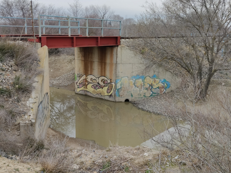
The issue of puddles may seem minor, but at least during the last cold season (2023/2024), from October to April, there were three difficult-to-pass areas at various points on my usual route, meaning the problem goes beyond just getting the bike dirty. One of these points is the railroad bridge that accesses Montañanesa as it crosses the path running along the right bank of the Gállego. Fortunately, I discovered that shortly before that point, a path branches off to the right, allowing you to pass under the bridge through one of its smaller arches further ahead.
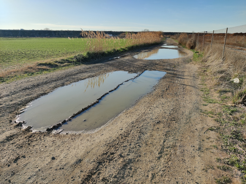
Another even worse crossing, given that there is no alternative once you are there (it is between a fence and a field that is sometimes non-cyclable), is at a point on the path very close to the previously mentioned bridge. Throughout these cold months, there were ponds whose edges remained permanently muddy due to the water displaced by passing vehicles. In the worst moments, the alternative was to take a slight detour up the Cogullada road to access the path that runs on the other side of the railway and thereby avoid the bridge.
Cold and Night
In winter, the main enemies are cold hands and lighting. For the former, I’ve tried many models of gloves, both heated and non-heated, and it wasn’t until I purchased the latest ones that I managed to solve the problem. Unfortunately, at the time of writing this article, they are not available for sale, although this might be due to the winter season not yet starting. They are the "HEAT CONCEPT BIKE" model from the brand Ekoi.
As for lighting, some time ago I bought a powerful light (similar to this one) for summer night rides. I started having problems with the battery, but from what I’ve seen, the battery format is quite standard or popular (8.4V), so I was able to easily find a replacement.
Increased risk of punctures
Here, I can only offer the natural recommendation to carry a pump with you, at least to be able to inflate the tire in case of a puncture until reaching your destination. In my case, I have my tires set up tubeless, which I recommend despite the inconveniences it has (it requires maintenance and it's much more cumbersome to remove the tire). Thanks to this, I have been able to forget about punctures for years (except for a couple of dramatic episodes where the tire would have been destroyed regardless of the tire type).
Longer travel times
Using rural paths takes more time, partly due to the slower travel speed and partly due to detours required to connect tracks. Although, as can be seen on the final map with the routes, most are quite direct.
Initial orientation
Related to the previous point, there's the possibility of getting lost, at least during the first few days, especially when using rural paths, as there's no signage and the paths/fields look similar. The first day I attempted to bike to the campus was a disaster. I had to improvise near the campus because the route I had pre-mapped with Google Maps led me to a blocked fence. That day I spent an extra hour circling through wild terrain between the Gállego river and the campus area, and later on, crossing some waterlogged fields that seemed like a good shortcut option 🤦.
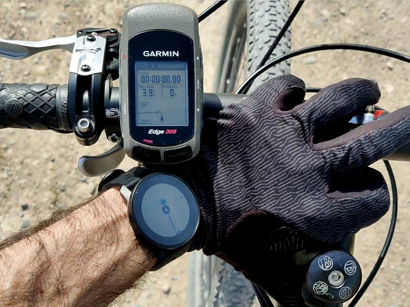
To avoid this problem, on one hand, it's advisable to use the appropriate tool to plan the route, which is not Google Maps as my colleague Miguel taught me, but another based on OpenStreetMap like GraphHopper where the campus perimeter is correctly mapped. On the other hand, it's advisable to carry a GPS device that allows us to follow the route without having to stop and check the map. In my case, I started using an old Garmin Edge 305. Now that I know all the different options by heart, I can lend it to other people who are encouraged to bike to the campus so they can learn the route. If you have a handlebar mount for a smartphone, you can also use a navigation app like OsmAnd with preloaded tracks.
Routes
Below is the collection of routes I have selected. One of the objectives of the selection has been to cover different starting points scattered throughout the northeast of Zaragoza. Another objective is to have options that run entirely on asphalt, either for days when the paths are muddy or for people who only have road bikes. The estimated time shown in the table is an approximation that may vary depending on physical fitness, bike type, and weather conditions (hello Zaragoza wind!). The observations column indicates any problematic points or factors to consider on each route. Finally, the first column contains a link to download the GPX tracks so they can be installed in applications such as the mentioned OsmAnd.
| Route | Distance | Estimated time | Observations |
|---|---|---|---|
| Juslibol/Actur - Campus (by San Gregorio) | 14,38 km | 40m-1h | You have to cross the Huesca road, but it can be done via an overpass. 🚧 |
| Arrabal/Picarral - Campus (by Corbera Alta) | 13,05 km | 35m-55m | 🚧 |
| Cogullada - Campus (Cogullada road) | 9,95 km | 30m-45m | Low traffic. 🚧 |
| Azud - Campus (right bank of Gállego) | 13,00 km | 35m-55m | The most fun. 🚧 |
| Azud - Campus (left bank of Gállego, asphalt) | 12,05 km | 35m-50m | In my opinion the best option, offers a good balance between speed, few cars, bike cleanliness, and the possibility to finish entirely on asphalt. |
| Azud - Campus (left bank of Gállego, rural paths) | 11,73 km | 35m-50m | Parallel to the previous one, without cars but it dirties the bike more. 🚧 |
| Azud - Campus (all asphalt) | 13,08 km | 35m-55m | It has a section shared with road traffic from Montañanesa to the entrance of Camino el Saso. |
| Azud - Campus (all asphalt 2) | 12,12 km | 35m-50m | It has a section shared with road traffic from Santa Isabel to Montañana. |
| Azud - Campus (all asphalt 3) | 13,02 km | 35m-55m | There is only a small section along the Montañana road but have a shoulder. |
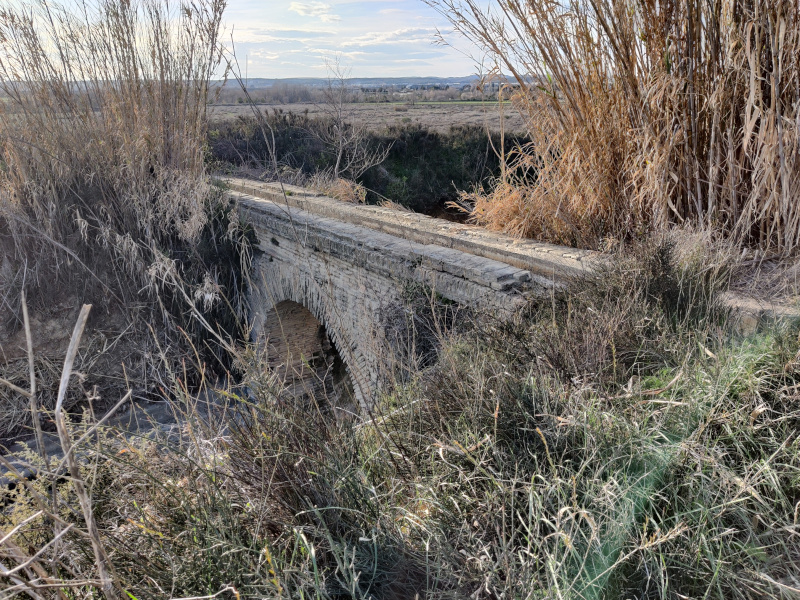
The emoji 🚧 in the observations of some routes in the table means that you have to cross the aqueduct over the Urdán canal. This is the aqueduct in the photo. It can be a bit tricky to pass with the bike, especially when it's carrying water or wet, as it becomes slippery and it is narrow. If it's not clear, you can cross to the other side of the canal via a level crossing further ahead, about 400m away.